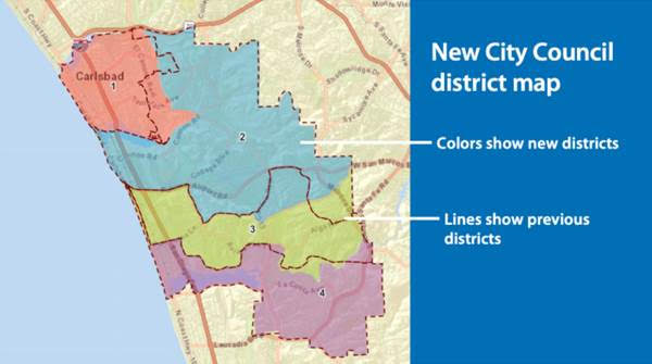
The City of Carlsbad’s Independent Redistricting Commission has selected a new City Council district map, which will determine the neighborhoods grouped together for the purpose of electing a City Council member starting this November.
Of the final maps considered by the commission, the approved map makes the fewest changes overall. In addition to adjusting boundaries to balance the population, commissioners moved some lines so that more neighborhoods could be together, including:
Moving an area north of the Agua Hedionda Lagoon near Kelly Elementary School from district 2 to district 1.
Adjusting the southeast boundary of districts 2 and 3 so residents north of Poinsettia Lane are together in district 2, and residents south of Poinsettia Lane are in district 3
Adjusting the border of districts 3 and 4 so it generally follows San Marcos Creek
With the changes in boundaries, about 13,500 residents have been shifted into a new district. About 3,800 registered voters who would have voted for their City Council member this year will now vote in the 2024 City Council district election.

What does the new map look like?

Community members can take a closer look at the new district boundaries on the city’s website.
When does the new map go into effect?
The new map went into effect as soon as it was approved. In the coming weeks, the City Council will update its municipal code to reflect the new map.
Which districts are up for election in 2022?
Council members serve staggered four-year terms. Districts 1 and 3 are up for election this year. Districts 2 and 4 will be up for election in 2024.
How do I know if my district has changed?
Residents can find their district by looking at the new map on the city’s website.
How was the map selected?
The Carlsbad City Council decided to appoint an independent commission to choose a new City Council district map based on federal and state criteria and community input. Commissioners were chosen through a random drawing based on criteria established by the state and the City Council.
The City Council also directed staff to go above and beyond the public outreach required by law to encourage Carlsbad community members to get involved in the process, which happens just once every 10 years, following the Census.
In all, community members submitted more than 75 draft maps for consideration as well as hundreds of ideas about how to adjust district boundaries. The city’s professional demographer created twelve maps through an iterative process that took into account community input and commissioner feedback.
How will the change affect existing City Council members?
Based on where existing City Council members live, the new map will not change their districts. However, their districts will now include some areas that weren’t included previously. Likewise, some areas in their districts previously might now be in a different district. The goal of the new map was to balance out the population among the four districts.
Why did the map need to change?
District lines must be reviewed every 10 years to ensure each district has about the same number of residents based on the latest census data. The City of Carlsbad switched to district elections in 2017 using the latest census data at that time, which was from 2010. The current map reflects changes in population from 2010 to 2020
More information
Visit www.carlsbadca.gov/districts.
Contact the City Clerk’s Office at 760-434-2808 or redistricting@carlsbadca.gov.


