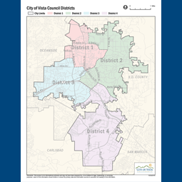
In June 2017, the Vista City Council voted to change the way City Council members are elected, creating four districts within the city and adopting a district boundary map. The district maps are required to be reviewed every 10 years based on the latest federal census data to reflect how local populations have changed and to ensure that all districts have about the same number of residents of voting age.
The City of Vista is beginning the redistricting process using the 2020 federal census data. Several public hearings will be held from mid-December through early 2022. The final map will incorporate the public’s input and will define the four City district boundaries. Those district boundary lines will impact how residents elect their council members for the next 10 years.
Why does redistricting matter to me?
Redistricting determines which neighborhoods and communities are grouped together into a district for purposes of electing City Council members. The map on this page reflects the current City Council districts.
How Do I Get involved? Share your thoughts, draw a map, attend an upcoming workshop or public hearing to get involved, or submit written testimony about the process or a specific map to EMAIL.
Go to CityofVista.com/districts for the calendar of workshops and public hearings, information on drawing and submitting a map, and submitting written testimony about the process or a specific map.
What is the Process?
The City has hired a demographic consultant from National Demographics Corporation, to draw the district maps based on the community’s input for consideration according to the requirements of the Federal Voting Rights Act and CA Voting Rights Act. In spring, 2022, the final district boundary map will presented to the City Council for adoption.
I: CityofVista.com/districts I 760.639.6125
First Redistricting Public Hearing
Tuesday, Dec 14, 2021 at 6:00 PM
Vista Civic Center, 200 Civic Center Drive


